-
AI Automation services
Cybersecurity
Cloud services
MVP Development
Full-stack Development
Custom Applications
-
Engineering Services
-
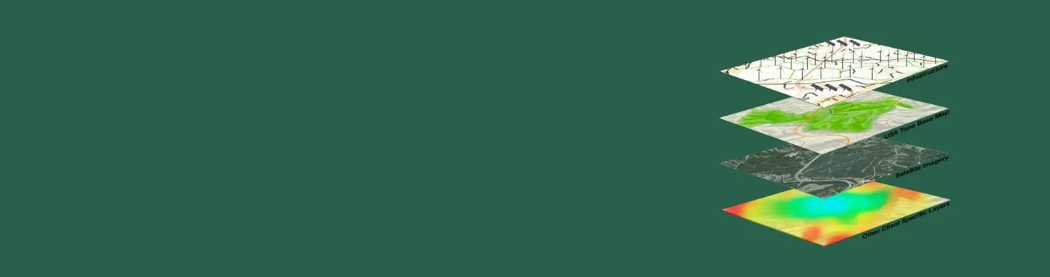
Polosoft Technologies is a well-known GIS Company that offers clients all around the world a variety of GIS services. Our GIS mapping services provided by us allow users to visualize geographical data, perform analysis and manage data efficiently.
Being a GIS company, after using the gathered data, we work on data conversions and create electronic maps using GIS technology. With the aid of top-notch GIS mapping and GIS data conversion tools, our experience enables us to combine GIS services with CAD services. Our customers can create spatial maps, atlases, contour maps, thematic maps, cadastral maps, landscape maps, zonal maps, and environmental maps with the aid of these services.
Data utilization is essential to GIS services since it enables the production of precise, detailed maps and the analysis of a variety of spatial and geographic data.

A flawless visual representation of the data is provided by GIS surveys. An outstanding illustration of a web-based GIS mapping tool used for navigation is Google Maps.

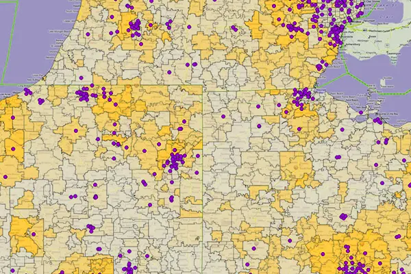
GIS data is used by organizations to simplify difficult network design, optimization, planning, and maintenance tasks and improve telecom processes.

Accident sites can be located using GIS data, and road networks are frequently improved by utilizing data intelligence to increase traffic safety.

Urban growth and, thus, the direction of expansion are analyzed by GIS data. Identify fresh locations for development while taking into account elements required for effective construction.

GIS data assists in managing transportation issues. Using gathered environmental and current data, businesses plan new road or rail lines.

Data gathered via GIS applications assists in conservation of natural resources and protecting the environment by assessing the magnitude of human impact on the environment.

GIS survey data contributes to the development of more productive and efficient agricultural methods, as well as the sophisticated analysis of soil data that results in increased food output.

An effective GIS system safeguards the environment and is designed to help with any potential risk and catastrophe management.

GIS data is used in web-based navigation maps to provide the general public with helpful information. Web maps are frequently updated based on GIS data.

Governments map flood-prone areas using GIS data, and they can access information to plan relief operations for the impacted areas.

GIS provides a powerful set of tools for collecting, storing, analyzing, and visualizing geographically referenced data to manage and analyze natural resources.
GIS data plays an essential role in planning, and decision making in the banking sector which has evolved as a market-driven industry.

Building permits and engineering are made possible by GIS, which helps the government manage property taxes in a specific area, find solutions to taxation issues, and increase tax revenue.

GIS surveying entails determining the locations of things on Earth and integrating GNSS and GIS systems to estimate areas and create digital maps.

Geologists analyze seismic data, conduct soil studies, and create 3D visualizations of geographical characteristics using GIS data. It is also sometimes used to examine the properties of rocks.

Maintenance helps to efficiently direct the physical performance of maintenance equipment and operations, while asset management aids in the analysis of all the data for the work that needs to be done.

GIS data enables us to understand and address global issues. There are numerous cutting-edge uses within the planning industry for GIS technology, which is developing quickly.

Crop productivity in a specific area is directly influenced by the water resources available. GIS data can identify important crops and calculate production using effective methods for the geographical and temporal domains.
To increase high levels of productivity, Polosoft Technologies provides Point Cloud Classification services for various industries.


Polosoft Technologies is a trustworthy and effective partner, for a company that needs high-quality LiDAR data processing services.

Grow Business Recognize opportunities, estimate precisely, and bid with assurance.

Strategy The science of securing future success, a system of intensive application.

Collaborate Engage powerfully using visual language that vividly illustrates your story.

Visualization Converting your imagination in to a creative successful design.

Quality Quality is everyone’s responsibility, and improvement is something to be prioritized.

Deliverable Scheduling a number of tasks to ensure the completion of each project.


Whether you need to streamline a process or develop apps fast, we're here to help.
Contact Us

 AI &
Automation
AI &
Automation
 QA & Software Testing
 Cybersecurity
 Cloud Services
 MVP Development
 Custom
Applications
Custom
Applications 


 Engineering Services

 Digital Branding
 Industries


 Home
Home


