-
AI Automation services
Cybersecurity
Cloud services
MVP Development
Full-stack Development
Custom Applications
-
Engineering Services
-

The goal of Polosoft Technologies when building its LiDAR classification and Vectorization wing was to inspect transmission lines in order to find and eliminate hidden threats. This becomes an important task for urban or rural power supply management, vectorization, and scientific planning.
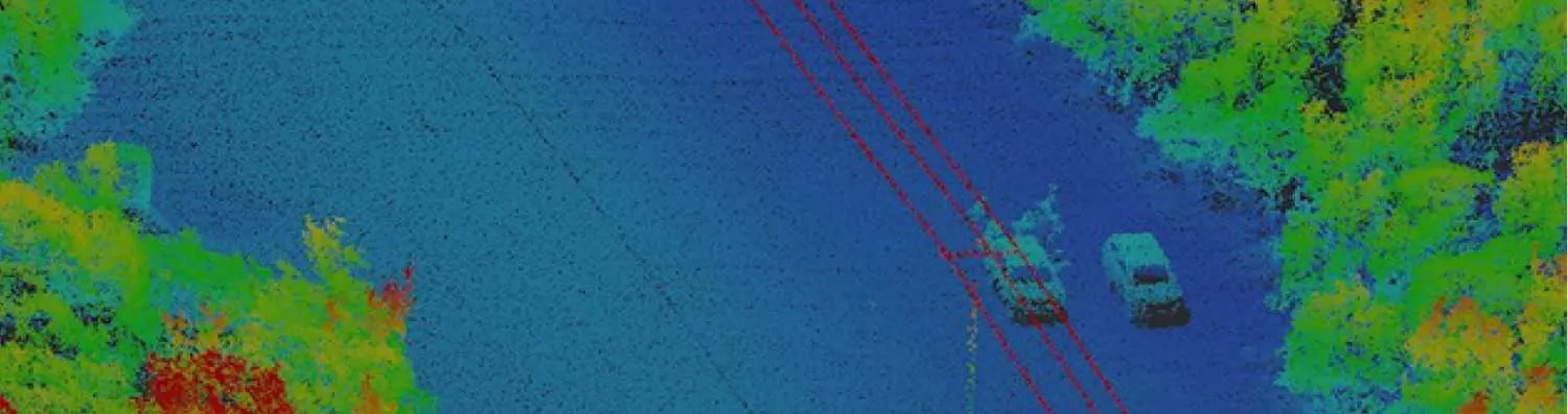
Airborne and Mobile LiDAR data make it simple to gather high-precision 3D point data for the mapping of powerline corridors. In order to reliably and quickly extract the powerline points from the LiDAR point cloud categorization, it can be difficult because powerlines can be extremely close to vegetation, buildings, and other infrastructure. Therefore, a crucial area of research and development for us is the development of quick automated methods for data extraction of powerline from airborne lidar point cloud data.
Feature extraction in powerline classification involves identifying and quantifying specific characteristics or attributes from LiDAR data that are relevant to powerline infrastructure.

Extracting height-related attributes such as elevation, height above ground, or relative height differences to differentiate powerlines and associated structures from surrounding terrain or vegetation.

Utilizing intensity values captured by LiDAR sensors to distinguish powerline components based on their reflectance properties. Higher intensity values often correspond to metallic surfaces of powerlines and hardware.

Analyzing point density distribution to identify densely clustered points corresponding to power line structures, conductors, or insulators. Sparse point density may indicate vegetation or terrain.

Calculating slope and curvature metrics to characterize the terrain surrounding powerlines. Steep slopes or significant curvature changes may indicate potential hazards or obstacles requiring attention.

Quantifying geometric properties such as linearity, straightness, or curvature of powerlines and associated structures. Deviations from expected shapes can indicate anomalies or structural issues.

Considering spatial relationships and contextual information to refine feature extraction. For example, assessing proximity to roads, buildings, or vegetation can help differentiate power line components from background clutter.

Detecting vegetation points within the LiDAR data and measuring their proximity to powerlines to assess vegetation encroachment risks including vegetation height, density, and distance to power lines are relevant.

Identifying specific components of powerline infrastructure, such as poles, towers, cross arms, insulators, and conductors, based on their geometric characteristics and spatial arrangement.

Estimating clearance distances between powerlines and surrounding objects or terrain features to ensure compliance with safety regulations and mitigate risks of contact or interference.

Analyzing changes in LiDAR data over time to monitor powerline infrastructure, such as sag detection, vegetation growth, or structural degradation.

Mapping the entire powerline corridor, including right-of-way boundaries and any obstacles that may affect maintenance or pose risks.

Assessing the terrain along the powerline route for elevation changes, slopes, or other topographic features that may impact infrastructure stability.
Powerline Classification and Vectorization Services offered by Polosoft Technologies encompass a range of advanced LiDAR data processing techniques.

By putting the transmission corridor's aerial LiDAR point clouds on the horizontal plane. The ground's vegetation, dwellings, and other mixed points are referred to as surface points, and these points are added to surface powerlines and towers.

The core of any powerline safety detection and the operating regulations for overhead transmission lines requires line inspection to ensure that the distance from the powerline to the necessary distance for safety is met at a corridor with a variety of elements.

After densely sampling the earth's surface with laser light, LiDAR produces data that yields extremely precise x, y, and z measurements. Mass point cloud data points produced by LiDAR can frequently be handled, displayed, analyzed, and shared.

The bare land or ground, the very top of the canopy, the surface of the water, and below are only a few of the categories into which LiDAR points are divided. The LAS files include numeric integer codes that define the various classes.

Standard deviations like 3cm to 1σ (sigma) or calculations of ± 2 cm are typically used to show precision. The LiDAR system assesses the precision of several sensor readings to a single cloud point before comparing it to the actual environment.

The time limit in which the job is delivered is the most crucial component of a project. Teams of committed individuals examine the provided data and background knowledge to ensure that the project is implemented perfectly overall.
The perfect methodology for powerline classification integrates cutting-edge technology, advanced algorithms, and precise data processing techniques. Here's a comprehensive approach:

Utilize airborne or mobile LiDAR systems to capture high-resolution point cloud data of the power line corridor. To capture detailed information, ensure optimal acquisition parameters such as point density, scan angle, and pulse repetition rate.

Clean the raw LiDAR data by removing noise, outliers, and artifacts. Correct for sensor distortions, such as scan angle effects or range biases, to ensure accurate representation of the powerline infrastructure.

Segment the LiDAR point cloud into relevant classes, such as ground, vegetation, buildings, and powerline components, using advanced segmentation algorithms like region growing or voxel-based methods.

Extract geometric and radiometric features specific to powerline classification, including height, intensity, slope, curvature, and point density. Utilize feature extraction techniques tailored to identifying powerline structures, conductors, insulators, and associated components.

Incorporate contextual information, such as spatial relationships and geometric constraints, to refine classification results and improve accuracy. Consider neighboring points or objects to validate classifications and resolve ambiguities.

Integrate classified point cloud data with Geographic Information Systems (GIS) for visualization, analysis, and decision-making. Utilize GIS platforms to manage and display classified features within the broader utility infrastructure context.

Validate classification results through ground truth verification or comparison with existing utility records and aerial imagery. Conduct quality assurance checks to ensure consistency, completeness, and accuracy of classified features.
Continuously refine the classification methodology through iterative testing, validation, and optimization. Incorporate feedback from field validation surveys and operational experience to enhance algorithm performance and reliability.
To increase high levels of productivity, Polosoft Technologies provides Point Cloud Classification services for various industries.


Being a well-known LiDAL company, Polosoft Technology has a significant role in LiDAR classification . We offer customers all over the world specialized, professional LiDAR services. The list of services we offer includes aerial, mobile, and drone LiDAR, and it keeps growing as more industries, like forestry, transportation, flood mapping, and the environment, join our roster of clients.
Our professional teams are capable to understand the requirements and process for new projects quickly. We ensure project deliver in time and faster with our stringent quality checking process. Get in touch with us via email.
Why is powerline classification important in LiDAR data analysis?
Power line classification in LiDAR data analysis is crucial for utilities and energy companies to accurately locate, monitor, and maintain their powerline infrastructure. It aids in assessing vegetation encroachments, identifying potential safety hazards, and planning for maintenance and upgrades.
How does powerline classification work in LiDAR data processing?
Power line classification involves extracting the geometric features of powerlines from the LiDAR point cloud data and applying classification algorithms to differentiate them from other objects and terrain features. This process utilizes the unique characteristics and patterns exhibited by powerlines in LiDAR data.
How accurate is powerline classification using LiDAR?
The accuracy of powerline classification using LiDAR depends on various factors, such as the quality of LiDAR data, classification algorithms used, and the level of manual validation. With advanced processing techniques, powerline classification can achieve high accuracy levels, typically exceeding 90%.
What are the applications of powerline classification using LiDAR?
Power line classification using LiDAR finds applications in vegetation management, corridor planning, maintenance scheduling, clearance analysis, infrastructure monitoring, and overall asset management for utilities and energy companies.
Can LiDAR powerline classification help in detecting encroachments?
Yes, LiDAR powerline classification can aid in detecting vegetation encroachments near power lines. By accurately identifying powerline features and assessing their proximity to vegetation, utilities can take proactive measures to address encroachment risks and mitigate potential hazards.


Whether you need to streamline a process or develop apps fast, we're here to help.
Contact Us

 AI &
Automation
AI &
Automation
 QA & Software Testing
 Cybersecurity
 Cloud Services
 MVP Development
 Custom
Applications
Custom
Applications 


 Engineering Services

 Digital Branding
 Industries


 Home
Home