-
AI Automation services
Cybersecurity
Cloud services
MVP Development
Full-stack Development
Custom Applications
-
Engineering Services
-
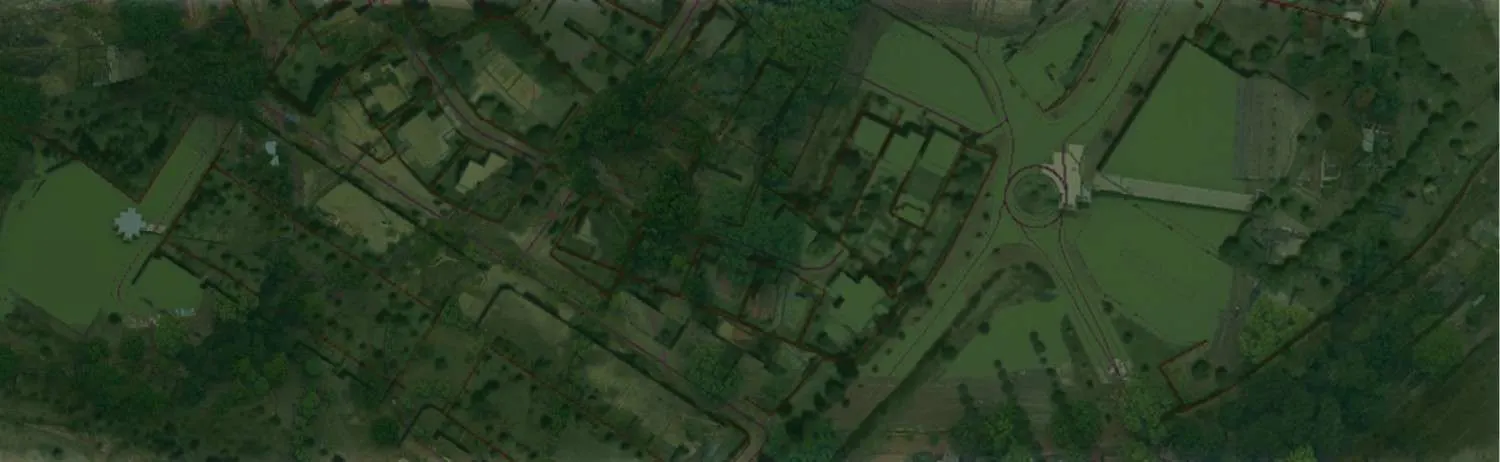

Digital Photogrammetry is the science of capturing pictures of the surface and generating digital terrain models (DTM), digital elevation models (DEM), digital surface models (DSM), 3D land models, etc.
While aerial imagery helps with accurate measurement of land features, surface models and volumetric data, photogrammetric surveys provide an efficient and cost-effective means of developing topographic mapping for your project.
Using the most recent aerial and satellite photography gear, software, and cutting-edge technology, Polosoft Technologies provides photogrammetric services from aerial photos and stereo satellite images. Polosoft offers digital photogrammetric services that meet the needs of the user with the highest level of simplicity and at a price that is globally competitive. The solutions are developed to order and cater to the unique requirements of the clients.
Polosoft Technologies provide comprehensive digital photogrammetry services that harness the power and do mapping for a wide range of applications.

Aerial triangulation is the term applied to the process of determining x,y and z Ground coordinate of individual points on measurements from the photograph.

Planimetric maps help in developing natural features with their exact coordinates and locations. These features consist of vegetation, curbs, trails, fences, utility poles, etc.

An aerial photo that has had the camera tilt and ground relief distortions removed. An orthophotography has an equivalent scale and may be used as a map.

Using airborne light detection and ranging, LiDAR provides precise digital mapping projects with highly accurate base map information with promising potential to assist maps.

With our vast collection of stock photos and historical imagery. Any and every of these images can be requested in print or digital format at any specific size.
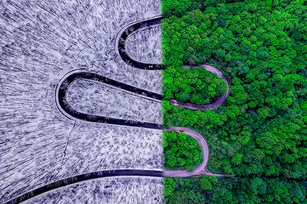
We use aerial photography as a way to extract cartographic data source for base map, locating geo features, & interpreting environmental conditions.

Mapping of land surfaces, including relief (relative positions and elevations) and therefore the position of natural and constructed features.

The regular array of z-values, related to a common datum, represents continuous elevation measurements over a topographic surface.
To increase high levels of productivity, Polosoft Technologies provides Point Cloud Classification services for various industries.


What is digital photogrammetry?
Digital photogrammetry is a technique to acquire 3D geometric information of real-world objects from stereoscopic image overlap and with extensive use in a variety of fields.
What are the types of photogrammetry?
Aerial Photogrammetry and Terrestrial Photogrammetry are two types. The first used in aerial topographic mapping and other starts with a camera mounted on ground.
What is the use of digital photogrammetry?
Used in reconstruction of objects and environments in the physical world through photographs. Stitching together overlapping photographs for 2D and 3D digital models.
What are the advantages of digital photogrammetry?
It eases and speeds data collection. With integration of UAV, UAS, or satellite imagery, photogrammetry helps in capturing images, analyze the data for measurements.
What is a digital photogrammetry system?
Digital photogrammetric system is defined as hardware-software designed to acquire photogrammetric data from digital imagery using manual or automated techniques.
Why are Digital photogrammetry services important?
It is highly accurate for mapping or other purposes providing a wide or broad view of the mapped area by utilizing both topographic and cultural features of the land surface.
Why do companies need Digital photogrammetry?
Photogrammetry uses both vertical and oblique photos for an accurate image of the terrain helping in 3D mapping of an area. Easily accessing difficult areas, mapping the terrain which even includes underwater terrains as well.


As a provider of Digital Photogrammetry Services in GIS, Polosoft Technologies provides for an individual GIS consultant for smaller tasks or a professional team of consultants for large-scale GIS enterprise consulting . With our tailored GIS services our GIS specialists, developers, and designers are experienced in providing industry specific solutions influencing the sphere and paving the path of development.


Whether you need to streamline a process or develop apps fast, we're here to help.
Contact Us

 AI &
Automation
AI &
Automation
 QA & Software Testing
 Cybersecurity
 Cloud Services
 MVP Development
 Custom
Applications
Custom
Applications 


 Engineering Services

 Digital Branding
 Industries


 Home
Home