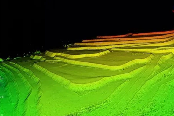
GIS for Mines Mapping and Analysis

Polosoft Technologies’ Geospatial Services for Mining Industries offer a transformative approach to navigating the complex world beneath our feet. We harness the power of geospatial data including Light Detection and Ranging (LiDAR) and Geographic Information System (GIS) data to offer a wide range of services that help various mining operations.

LiDAR's high-resolution, real-time data assists in precise site modeling, hazard detection, and topography analysis, and GIS data's ability to seamlessly merge geological, topographical, and environmental information empowers mining professionals to make data-driven decisions, from assessing the most viable ore deposits to designing the most efficient transportation routes. With our Geospatial services, you can enhance operational efficiency, reduce costs, and minimize environmental impact by identifying and addressing potential issues in real time.

Mineral Resource Exploration

Exploration is the foundational stage of any mining endeavor, and GIS data helps mining professionals explore mineral resources with unparalleled precision and efficiency.

/prospecting-and-land-use-planning

Prospecting and Land-Use Planning

In order to identify viable mineral deposits, GIS data allows mining experts to collect and organize important geological and environmental information in one place. With this information, they can carefully plan how to use the land and assess whether mining projects are feasible.

mobile-work-and-data-collection

Mobile Work and Data Collection

Exploration starts with gathering accurate observations in the field. GIS data collected in real-time is merged and integrated into a common platform. This helps in creating successful exploration campaigns, which as a result allows mining professionals to make informed decisions and maintain the integrity of their data.

mapping-and-analysis

Mapping and Analysis

The data collected through GIS is then used for mapping, which enables geoscientists to integrate, interrogate, and analyze data effectively. This reduces the risks involved in exploration and helps mining professionals make better decisions.

managing-data

Managing Data

Data management is key to the success of exploration and provides a solid base for the rest of the mining journey. Exploration and mining company leaders can rest assured that with our services their GIS data are secure and well-maintained at all stages of the mining life cycle.

Operations: Enhancing Mining in Real Time

The operational phase of mining is where efficiency, safety, and profitability come together. GIS data is vital in transforming mining operations into a well-coordinated, streamlined, and data-driven endeavor.

blasthole-planning

Blasthole Planning

Maps made from GIS data enable crews to accurately log and position drilling holes while collecting critical pre- and post-blast information. This data can be instantly linked back to mine planning engineers, ensuring a more controlled and effective blasting process.

haul-road-conditions

Haul Road Conditions

Real-time monitoring using GIS allows operations to identify areas causing delays and direct crews to maintain better haul road conditions. This increases the efficiency of material transport and reduces equipment repair and downtime, leading to cost savings and enhanced safety.

heap-leaching-process-monitoring

Heap Leaching Process Monitoring

By visualizing and analyzing GIS data and maps staff can analyze and track the material rate and type effectively. This makes sure that the heap leaching process is both efficient and environmentally responsible, reducing waste and maximizing ROI.

tailings-storage-facility-management-tsf

Tailings Storage Facility Management (TSF)

GIS data-driven maps provide a comprehensive view of TSF health by consuming and combining key performance indicator (KPI) data streams, including imagery, sensor data, and field inspection information. This improves monitoring and early issue detection, ensuring responsible waste management in mining operations.


Environmental Health and Safety

GIS data is an invaluable tool for mining companies to optimize their safety measures and environmental responsibilities.

environmental-monitoring

Environmental Monitoring

Visualizing and analyzing geospatial environmental data is essential for monitoring air quality, groundwater conditions, and other environmental factors. GIS allows mining professionals to explore historical trends in sampling data, which helps in identifying potential issues.

inspections

Inspections

By visualizing and monitoring inspection data, staff can reduce risks and maintain environmental compliance. Automated report creation, email notifications, and alerts lead to efficient record-keeping and quick response times.

mine-reclamation

Mine Reclamation

From mine closure to reclamation and reseeding, GIS data plays a pivotal role in the bond release process. It streamlines regulatory reporting and ensures that mine operations proceed while following the guidelines of state and federal agencies.

Looking for Professional Approach and Quality Services ?

Contact Us Today

Geospatial Data Services for Mining

Polosoft Technologies’ LiDAR data services help shape the future of mining, making it safer, more cost-effective, and environmentally conscious.

accurate-volume-calculation

Accurate Volume Calculation

By capturing detailed 3D data of mining sites, LiDAR data aids in determining the exact quantities of material excavated or stored, streamlining the logistics and resource allocation processes.

infrastructure-analysis

Infrastructure Analysis

LiDAR's ability to capture high-resolution, real-time data helps mining operations analyze structures, access routes, and machinery with utmost detail. This leads to better maintenance, cost savings, and increased safety throughout the mining facility.

extension-planning

Extension Planning

Through detailed topographical mapping and spatial analysis, LiDAR data enables mining professionals to identify the most viable sites for extension, resulting in an environmentally conscious planning process.

pre-post-mining-survey

Pre/Post Mining Survey

LiDAR data helps mitigate the impact of mining on the environment by facilitating comprehensive pre- and post-mining surveys. Its ability to provide high-resolution, real-time data ensures that mining companies obey environmental regulations.

the-face-of-stope-monitoring

The Face of Stope Monitoring

LiDAR’s continuous data on the stope's face helps in effective monitoring, ensuring that operations are conducted safely, and any potential hazards are promptly identified and addressed.

accesses-planning

Accesses Planning

LiDAR data aids in planning and optimizing access routes within the mining facility, by providing precise topographical data. This ensures efficient access planning, reduces delays, and improves overall productivity.

Revolution of Mining Begins with Us

In the mining industry, knowledge and data are the main requirements for success. Polosoft Technologies is your trusted partner, offering cutting-edge geospatial data services to empower your mining operations. From precise exploration and operational optimization to rigorous environmental health and safety compliance, our GIS services are going to transform the world beneath us. Our expert team is ready to guide you toward enhanced efficiency, reduced environmental impact, and heightened safety in your mining operations. Join us and redefine the standards for a sustainable, prosperous, and knowledgeable future.

FAQs

Q: What are geospatial services, and how do they benefit the mining industry?

A: Geospatial services involve the use of data like LiDAR and GIS to provide valuable insights for mining operations. They help improve safety, efficiency, cost management, and environmental responsibility in the industry.

Q: How does GIS data contribute to mineral exploration in mining?

A: GIS data is instrumental in collecting and organizing geological and environmental information. It assists mining professionals in the careful planning of land use and the assessment of project feasibility.

Q: What are some specific applications of LiDAR data in the mining industry?

A: LiDAR data is used for applications like precise site modeling, hazard detection, topography analysis, real-time monitoring, and volumetric calculations in mining operations.

Q: What are the key safety benefits of using LiDAR and GIS data in mining operations?

A: These technologies provide real-time hazard detection, improve safety monitoring, and reduce risks associated with mining, benefiting both personnel and equipment.

Q: Can you explain how GIS data supports efficient access planning within mining facilities?

A: GIS data provides detailed topographical information that is vital for planning efficient access routes. This minimizes delays and enhances productivity within the mining facility.

We Grow Together Worldwide!