-
AI Automation services
Cybersecurity
Cloud services
MVP Development
Full-stack Development
Custom Applications
-
Engineering Services
-

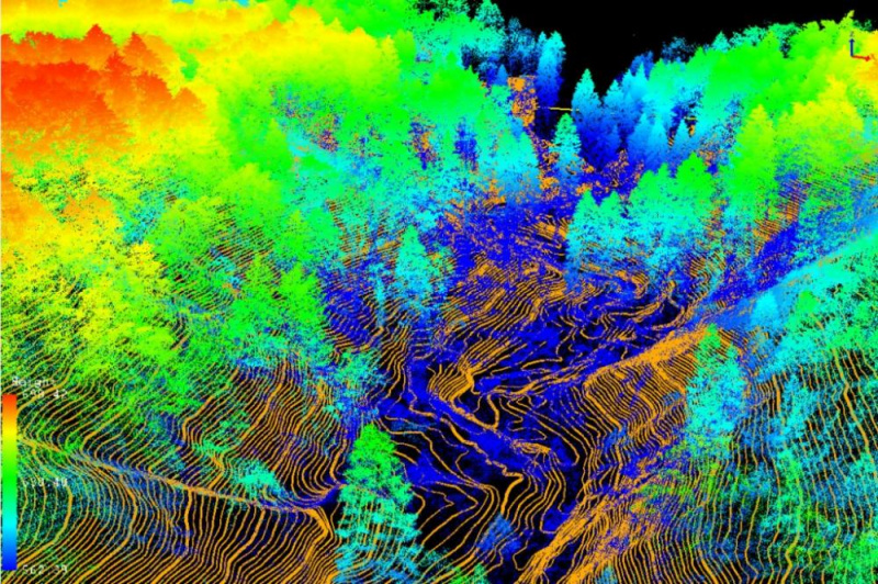
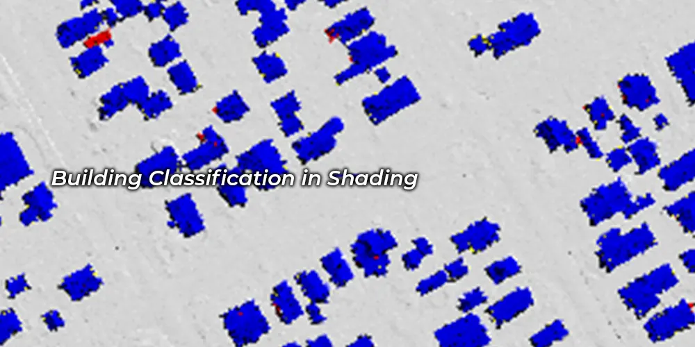
Point Cloud Classification might be related to our understanding of measurement instruments. Because it makes parcel mapping incredibly simple and accurate, services and area units are in high demand. When classifying clouds, various purposes area units are categorized by taking into account a variety of point cloud knowledge options, such as height, PCA, etc. Choosing points within the parcel that area unit on the bottom level offers an awfully clear and correct classification of various options on the bottom level like roads, power lines, cars, buildings, vegetation, etc.
All the features are showcased in different color which makes it very easy to understand and read.

Bare earth classification sifts through LiDAR data to identify points representing the actual ground surface. This separates ground from vegetation, buildings, and other features. It's crucial for creating accurate Digital Elevation Models (DEMs) used in terrain analysis, flood modelling, and infrastructure planning.

It leverages features like height, intensity, and return number to categorize points into intricate classes. This could involve separating power lines from trees, classifying different building types, or identifying individual plant species. This detailed data unlocks advanced applications in urban planning, forestry, and environmental monitoring.
The classification of a LiDAR point cloud is a crucial stage in the process of obtaining useful information from the data.

Fundamentally, a point cloud is a collection of XYZ data points. It is a sizable but sparse three-dimensional depiction of a scene. By extracting objects and classifying them — whether by adding color to point clouds or applying data tags, or both — you can more easily interpret and analyze their output. Classification has long been seen as a crucial stage in the reality capture process.

Although complete automation is imminent, it is not yet ideal. Users of the top point cloud categorization software should be able to enjoy both automatic and validated processes. Surveyors can manually verify the correctness of the classification made by algorithms after they have made a first pass. Any automated point cloud classification will include a sizeable portion of quality assurance of confidence assessments

Processing of point clouds is often migrating to the cloud. Any point cloud processing application is at home in the cloud thanks to its processing power, scalability, resilient infrastructure, and nearly limitless storage capacity. There will be an increase in the creation of cloud-native applications that can scale up and down as needed to complete tasks more quickly.

The combining of several scan output types will be more and more crucial for reality capture. By combining scanning techniques, each of which has its own strengths and weaknesses, the aim is to maximize the efficiency and effectiveness of the data capture tools at your disposal. Terrestrial laser scanners are excellent in accurately capturing data for a variety of industries, including the interiors of buildings, industrial facilities, and civil infrastructure.

Fundamentally, improved categorization automation will be achieved while maintaining quality control by using trust-but-verify systems and greater automation. Users should be able to access these technologies as they develop by fusing together capabilities from the top suppliers on demand if they invest in cloud-first platforms. These software services help teams extract intelligence from their point cloud data and will be continuously improved.

For accurate and exact information that defines details regarding the surface of the Land, point clouds produced by LiDAR are sufficient. The classification of point clouds provides an excellent source of information for precise GIS mapping since it enables you to identify and draw attention to abnormalities. We design workflows that make use of transformers that isolate the information you need and show any distant points to help you locate any rough spots.
To increase high levels of productivity, Polosoft Technologies provides Point Cloud Classification services for various industries.


The classification of LiDAR point clouds is crucial for measuring instrument services. Polosoft Technologies takes satisfaction in becoming a well-known name in the LiDAR industry without bragging. influencing industries and people everywhere. Our roots are deeply ingrained in many fields, including flood mapping and forestry mapping . LiDAR utility services have streamlined the path to a brand-new tomorrow, and Polosoft Technologies plays a significant role in that by offering specialized LiDAR services all over the world.
What is point cloud classification?
The point cloud classification is a process which is based on machine learning techniques required for training on labelled data. The geometry and the nature of the information are used to assign the points of the densified point cloud in one of the predefined groups.
What is a classified point cloud?
The classified point cloud for a user is a defined set of classes (e.g. vegetation, ground, roofs, etc.), in which the algorithm classifies the points by computing a set of geometric attributes and thus minimizing a globally regularized energy.
What is point cloud classification in LiDAR?
LiDAR points are classified into a number types which includes categories such as the bare earth or ground, top of canopy, and water. The classes are differentiated and are defined using numeric integer codes in the LAS files.
What do you mean by a point cloud image?
A point cloud image is defined as a set of data points in space. The points may be used to easily represent a 3D shape or object. Position of each point has its own dedicated set of Cartesian coordinates (X, Y, Z) mainly produced by using 3D scanners or by photogrammetry software which measures all the points on the external surfaces of objects around them.
What is the use of LiDAR point cloud classification?
LiDAR point cloud classification is a collection of data points curated using a 3D scanner or any photogrammetry software in a 3D coordinate system with x, y, and z coordinates. These coordinates are then used to represent the surface of any and every object with all of its external features.
Why do companies need LiDAR point cloud classification?
LiDAR point cloud classification enables easy storage and manipulation of precise 3D data. It provides a powerful aid to all industries, businesses or projects that depend on measurement data. It streamlines workflow, improves communication, and increases efficiency of data delivery.
Why is LiDAR point cloud classification important?
LiDAR point cloud classification is important because it helps to distinguish different types of objects in the LiDAR dataset, which is essential for accurate and meaningful analysis.
What are the different classes in the point cloud?
The different classes in LiDAR point cloud classification may vary depending on the application but typically include ground, vegetation, buildings, water, and other features of interest.
What are the applications of point cloud classification?
The applications of LiDAR point cloud classification include vegetation mapping, land cover classification, floodplain mapping, urban planning and development, and transportation infrastructure management, among others.
How accurate is point cloud data?
Generally, LiDAR point cloud classification can achieve high accuracy levels, ranging from 80% to 95% in many applications.


Whether you need to streamline a process or develop apps fast, we're here to help.
Contact Us

 AI &
Automation
AI &
Automation
 QA & Software Testing
 Cybersecurity
 Cloud Services
 MVP Development
 Custom
Applications
Custom
Applications 


 Engineering Services

 Digital Branding
 Industries


 Home
Home