-
AI Automation services
Cybersecurity
Cloud services
MVP Development
Full-stack Development
Custom Applications
-
Engineering Services
-

LiDAR forest and road tree scanning allow for the collection of 3D point cloud data using LiDAR technology and a scanning camera with various angles and resolutions. These point clouds enable us to, for example, retrieve data on the forest structure and the characteristics of each tree or to model each tree in three dimensions. Get specific details about forest and road tree classification with a complete process for your next project.
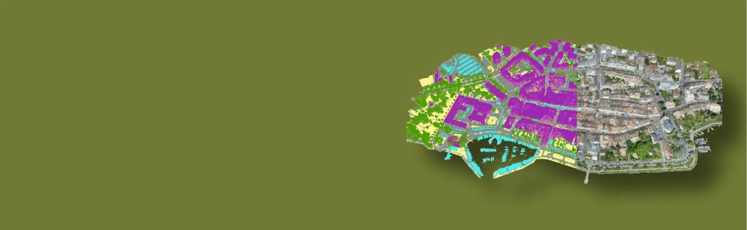
Forest cover classification is a process used to categorize different types of forested areas based on specific criteria such as vegetation type, density, and land use. This classification helps in understanding and managing forest resources, monitoring changes over time, and supporting conservation efforts. Techniques used for forest cover classification include remote sensing, aerial photography, and geographic information systems (GIS).

Individual tree point clouds were created automatically from the complete TLS and MLS point clouds. Nowadays various AI technological tools are also to be used but obviously, they lag with some of the finest data classifications.The point clouds were manually drawn to represent ULS and ALS tree point clouds.

A manual correcting process was used. Selective tree point clouds were compared to the surrounding segmented trees in order to identify and manually fix any incorrect or missing points. Polosoft will help to identify trees in better ways and classified data is of high quality.
The junction of the tree stem centre with the terrain is how we determine a tree's position. We first generated digital terrain models (DTMs) from the ALS point clouds in order to estimate the tree positions. The bottom of the tree point cloud, preferably the TLS or ULS point clouds, if they are available, is then sliced through. The generated positions were visually examined for quality control.

Tree metrics were also computed from the laser scanning point clouds and field observations. Only the TLS tree point clouds were used to estimate DBH. Numerous returns from the stems are recorded because of the terrestrial vantage point and near proximity, which enables precise DBH estimates.

Reflectance is calculated as the difference between the amplitude of the struck target and the target used to calibrate the sensor, which is a diffuse white target. The pulse shape deviation describes how much the received pulse 255 deviates from a reference pulse shape that is specific to the device.

All three platforms; ALS, TLS, and ULS were used to acquire the tree point clouds. Many data types are provided per tree for a variety of reasons: Only TLS point clouds of trees are available since TLS acquisitions only covered a portion of the ALS/ULS acquisitions rather than all of them.
We manually drew trees in the point cloud using the ALS and ULS point clouds using the interactive segmentation tools. Using retrieved template tree point clouds, automatic tree extraction from ALS and ULS point clouds is performed. We were able to use already extracted tree point clouds from one dataset to query points from another dataset since our laser scanning point clouds are spatially overlapped and co-registered.
Trees in the effective region and outside it are represented by point clouds.
A tree has been expertly digitised from all angles.
A tree near the perimeter of the effective area.
A tree of a similar size to the tree that is outside the effective area.
Canopy of trees overlapping to identify the tree's structure and overshadowing.
Canopy by falls has been segmented as Pole or other objects.
The truck of trees has been falsely segmented or classified as Pole.
To get comprehensive and accurate side information about trees, one can use data from Mobile LiDAR Data Processing. As a result, it can make it possible to extract certain tree metrics, such as tree height, crown size, crown base height, and breast height diameter, and it can offer fundamental information for forest study and management.


To ease technical challenges and boost process effectiveness, a top-down hierarchical segmentation approach.

In order to segment overlapped canopy, a modified node similarity calculation for the normalised cut approach.
Polosoft does have expertise in the extraction and classification of Trees for MLS data very well. We did projects for various utilities and Telecom companies to maintain a tree management system and were very well aware of the ASPRS classification system.


The target point cloud appears to be aligned with predicted deviations in the range.

Strip differences for the extracted plot point clouds for ALS were measured.

The precision of position and alignment using ULS point clouds. The TLS point cloud is used to choose the subset of points for which correspondences are formed and to which planes are subsequently fitted to reduce point-to-plane distances.
The precision of the segmentation of the tree point cloud and the point density of the tree point cloud determine the quality of the tree metrics generated from the LiDAR point clouds.
Since understory trees in particular have low point densities in ALS tree point clouds, the computed metrics may not match the field-measured metrics.

To increase high levels of productivity, Polosoft Technologies provides Point Cloud Classification services for various industries.


What is LiDAR technology, and how is it used in forestry management?
LiDAR (Light Detection and Ranging) technology is used in forestry to gather high-resolution spatial data about forests. It provides horizontal and vertical information with high accuracy, allowing for better forest monitoring, management, and planning.
How does LiDAR mapping contribute to forest management?
LiDAR mapping provides valuable information about forest components such as tree density, volume, and height. This data aids in forest surveys, enabling efficient forest management practices, including tree cutting for preservation purposes. LiDAR data is also used in fire behavior modeling, allowing accurate predictions of fire spread and assisting in fire management strategies.
What are the uses of LiDAR mapping in forestry?
LiDAR mapping has various uses in forestry, including improving forest management efforts and providing targeted source materials for the industry. It helps create detailed surface models for high-resolution data, supports accurate classification of ecological and land use information, facilitates complex forest structure analysis, monitors terrain patterns for potential fire risks, and enhances timber yield productivity.
How is LiDAR data utilized in fire behavior modeling for forestry?
LiDAR data, specifically CBD and CBH measurements, are utilized in fire behavior modeling for forestry. These measurements are combined with other variables such as elevation, slope, aspect, fuel models, and canopy cover to simulate fire behavior accurately.
How can Polosoft Technologies assist with forestry management?
Polosoft Technologies specializes in LiDAR mapping services for forestry management and mapping. They offer comprehensive LiDAR classification and have expertise in initial management and mapping through LiDAR technology. Their services, including drone and aerial LiDAR, contribute to improved forest management and pave the way for future advancements in the field.


Whether you need to streamline a process or develop apps fast, we're here to help.
Contact Us

 AI &
Automation
AI &
Automation
 QA & Software Testing
 Cybersecurity
 Cloud Services
 MVP Development
 Custom
Applications
Custom
Applications 


 Engineering Services

 Digital Branding
 Industries


 Home
Home