-
AI Automation services
Cybersecurity
Cloud services
MVP Development
Full-stack Development
Custom Applications
Mobility
-
Engineering Services
-


LiDAR technology permits the information capture on field by lighting the target employing a periodical optical maser. As measuring devices additionally provide elevation information, it finds applications in many industries. The measuring device will verify how objects are unit off from one another by shining an optical maser onto a target and analyzing the sunshine that bounces back. A measuring device is employed to form unbelievably elaborated maps additionally to aiding researchers within the fields of earth science, archeology, geology, seismology, region sciences, optical maser studies, and far a lot of.
Polosoft Technologies provides Digital Elevation Models (DEM), Digital Piece of Ground Models (DTM), and Triangulated Inverse Networks (TIN), which provide incredibly accurate detail of the Earth's surface and are created using a wide range of LiDAR data processing services. Our LiDAR services have helped industries in taking advice selections concerning their business. LiDAR drafting services change the electrical utility trade with the economical designing and maintenance of electrical networks. By helping with crop evaluation mapping and watershed delineation using measuring device-related cloud data, LiDAR categorization also supports the agricultural industry.
Our LiDAR services include a range of cutting-edge solutions designed to provide accurate and precise data for a variety of applications.
LiDAR services and data processing offers a number of benefits in a variety of industries.

LiDAR-equipped drones will reach the bottom surface through little openings within the cover, foliage and plant-life, capturing depth information that’s exhausting to gather by ancient ways.

Numerous applications, including urban planning, infrastructure design, natural resource management, and even archeological surveying, can make use of LiDAR services for extremely precise and detailed data.
With LiDAR drone technology for these types of applications, it is possible to achieve high accuracy and efficiency in measuring and monitoring volume changes over time, allowing for more effective management of resources and cost savings.

For our LiDAR services we employed commissioned professionals to make high-precision 3D models that deliver strong info impracticable with ancient means that, like finding the low points on farmland for irrigation designing.

Our LiDAR services use technology that captures crucial information that helps commissioned professionals shield and restore vulnerable coastlines and by flying a locality multiple times in progress patterns of abrasion, and outline shifts.

It will facilitate those professionals in in progress ROW encroachment observance by exposing tree canopies hanging over transmission lines, permitting plus managers to quickly pinpoint and address crucial service wants
LiDAR services typically involve a range of tasks, and compiling a comprehensive list of deliverables is crucial for ensuring that all project requirements are met.

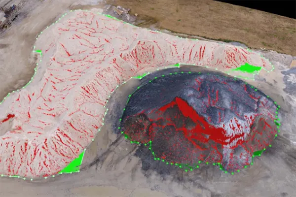
With LiDAR 3D point clouds are the cornerstone of precision mapping and analysis. These digital landscapes offer unparalleled insights into terrain, infrastructure, and vegetation, revolutionizing industries from urban planning to forestry management. Harnessing this technology empowers smarter decision-making and transformative innovation across diverse sectors. LiDAR data services sculpt intricate landscapes with unparalleled 3D detail, transforming spatial understanding.
We provide regular 3 dimensional DTM datasets by classifying and filtering vegetation, alternative on top of ground options. A real illustration of the vacant earth surface is pictured once non-ground points square measure off from the dataset. Filtered DTM is delivered in LAS, xyz, csv or the other shopper requested format. Digital Surface Models square measure georeferenced regular grid datasets representing the primary mirrored surface.


A high-resolution representational picture is captured in conjunction with measuring instrument information associated with ortho mosaic, then processed over the project space of interest. While these survey square measuring instrument capture, ortho mosaics are a helpful adjunct to the measuring instrument survey. Color ortho mosaic at project resolution cut to project two-dimensional figure and delivered in shopper chosen image format.
Building footprints are extracted from measuring instrument information as 2D or 3D georeferenced vector layers. Footprints depict the situation of buildings and may be used for sleuthing changes in building size, location, numbers and measurement of front, facet and rear setbacks. Building footprints is overlaid on associate orthophotography, that is additionally a by-product of our measuring instrument services.

To increase high levels of productivity, Polosoft Technologies provides Point Cloud Classification services for various industries.


What do you mean by LiDAR?
Lidar abbreviation for Light Detection and Ranging, is a remote sensing technique which is used to examine Earth’s surface. Light pulses when combined with other recorded data generate precise, 3D information about the shape of the Earth and all of its surface characteristics.
What is the use of LiDAR?
LiDAR is used in/for a wide range of projects on land management and planning which includes hazard assessment, forestry, agriculture, geologic mapping, and watershed and river surveys.
Is LiDAR active or passive in use?
LiDAR is a prominent example of active remote sensing as it can easily measure the time delay between emission and return, helping establish the location, speed and direction of any particular object.
What are the uses of LiDAR?
LiDAR has a very important role when it comes to archeologists, helping them to understand the Earth’s surface. LiDAR can easily detect micro-topography which is mostly hidden by vegetation in turn helping the archeologists to understand the surface of Earth. Ground-based LiDAR technology has an important aspect for capturing the structure of the building.
Is LiDAR a technology of the future?
LiDAR Is the perfect technology for Future Autonomous Driving to overtake the market. LiDAR makes It cheaper and better and is the right strategy to win market share as fully autonomous cars get closer to reality.
Why do companies need LiDAR drafting services?
For companies involved in real-estate and archaeologists around the world, LiDAR drafting services offer an incredibly accurate as well as consistent result when it comes to data extraction and analysis. The shorter wavelengths can even detect small objects and create exact ready-to-use 3D models, making it clear whether the objects are a tree, person, or a mere wall.
Polosoft Technologies is a trustworthy and effective partner, for a company that needs high-quality LiDAR data processing services.

Grow Business Recognize opportunities, estimate precisely, and bid with assurance.

Strategy The science of securing future success, a system of intensive application.

Collaborate Engage powerfully using visual language that vividly illustrates your story.

Visualization Converting your imagination in to a creative successful design.

Quality Quality is everyone’s responsibility, and improvement is something to be prioritized.

Deliverable Scheduling a number of tasks to ensure the completion of each project.


Whether you need to streamline a process or develop apps fast, we're here to help.
Contact Us

 AI &
Automation
AI &
Automation
 Cybersecurity
 Cloud Services
 MVP Development
 Custom
Applications
Custom
Applications 


 Engineering Services

 Digital Branding
 Industries


 Home
Home


