-
AI Automation services
Cybersecurity
Cloud services
MVP Development
Full-stack Development
Custom Applications
-
Engineering Services
-


Civil engineers depend on CAD drafting to design and modernized maps that emphasize different terrains. Land survey CAD drafting is an important part of the initial phase of any project. Polosoft drafting service involves designing 2D and 3D models of the area through computer software for better planning and prosecution of construction projects. Our CAD technicians are professionals with years of experience to design and update maps that consist of the complete layout of the project.
Polosoft provides a variety of land survey CAD drawing services. To assists survey professionals, and their company, we can work with many advanced tools and industry-standard software as per the requirement of clients for CAD drafting.
Polosoft feels glad to work with numerous architects, interior designers, civil engineers, space planners, contractors, builders, and real estate owners.
Efficient digital representations of land features empower informed decision-making and expedite project execution.

Measuring the building inside out by the use of accurate laser techniques and creating a drawing which portrays the perfect dimensions and layout of the building is termed as an As-built survey. Use an ALTA Survey for an Acquisition.

Maps with certain scales are used to represent the division of land on subdivision plats. These indicate lot and block designations on the plat. The boundaries of the easements, alleyways, and streets are shown over a plat.

To ensure the title to the real estate property, title surveys are carried out by Registered Land Surveyors working for a title insurance company. Title surveys are usually needed for real estate transactions.
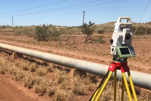
A pipeline survey is a method of evaluating the current state of sewage network and water distribution pipelines that run beneath a city and determining if the pipelines need to be repaired, replaced, or rehabilitated.

Construction surveying is beneficial for assessing the arrangement of the buildings, roads, power lines, gas pipelines and different structures surrounding potential construction sites for analyzing data for the construction.

A site planning survey is a sketch prepared with the data taken from a Survey. When creating a site plan or making other modifications to land, a boundary survey and a topographic survey are combined.

To ascertain the precise plotting undertaken on a landscape, a boundary and location survey is required. Both government and private landowner surveys employ this.

A topographic survey's goal is to collect data on a piece of land's elevation at various places and display it as contour lines.

Utility survey mainly comes into the picture in the utilities industries where surveys are needed to map the structure, electric poles, water pipeline, etc.

Investigative map CAD drawing is the method used in forensic analysis, urban planning, and environmental studies, where accuracy and detailed visualization are critical.

Tower surveys are examinations of a number of towers in a given location. From finding tower load to finding extra tower requirements, there are a number of reasons these surveys are conducted.

The radius map, which measures the length between the center of a circle and a point on its perimeter based on distance. Search by address or start using the map controls to navigate to your chosen location.
You should choose Polosoft Technologies with guaranteed exceptional results that meet and exceed your land survey drafting needs.


To increase high levels of productivity, Polosoft Technologies provides Point Cloud Classification services for various industries.


We are highly familiar with drafting requirements because we have experience working with many different states in the USA, including Texas, New York, New Jersey, Arizona, California, and many more. While working on time constraints and still maintaining the quality of drafting. Every project is different, and we recognize this, thus it is important for us to comprehend your particular needs. We will ensure that your drafting works go the way you want, and we will tailor our CAD drafting services accordingly to provide you with solutions ideally suited to your requirement.
We ensure accuracy and clarity throughout your land development projects with Polosoft's Land Survey CAD Drafting expertise. Our skilled professionals meticulously convert complex survey data into comprehensive 2D and 3D CAD models. Clear and detailed CAD drawings facilitate seamless communication between stakeholders, including engineers, architects, and contractors.
Polosoft's Land Survey CAD Drafting CAD Drafting services empower informed land development and pave the way for successful project completion. Contact us today to discuss your specific requirements.


What is land survey drafting?
Land survey CAD drafting becomes vital during any and every project’s initial phase. CAD Drafting services can involve and 3D model designing 2D of the area using a computer software for better planning and execution of construction projects.
Is it possible to make a model without a CAD file?
An important step in the CAD drafting is creating opportunities to work out the functional details on the screen before it becomes physical i.e. before building anything physically. Models and manufacturing technologies Polosoft uses are made into digital files created in the 3D using CAD softwares.
How do you communicate during a CAD project?
Polosoft focuses on communication of information with the clients. The project manager is thoroughly responsible for communicating clearly, effectively and at relevant times. A continuous communication network is maintained with you at all times keeping you on the same page as us about the project. Communication is simple and easy via email, phone, fax, or online chat and also a FTP transfer can be set up for our clients.
What about the data security during a CAD project?
Data security is not a concern with Polosoft, with a perfectly secured server and software database your CAD project is in safe hands.
Why is Land survey drafting important?
Maintaining maps and boundaries Marking locations & building corners Helping management of civil law Easing of property transactions
Why do companies need Land surveying drafting?
Land surveying is used to decipher a 3D position of points and the distances and angles between them. Same is used to make models for architecture, infrastructure, rural, urban or mining development.
Where to get a CAD company in the USA or around the world?
Polosoft Technologies provides CAD drafting services in the USA and around the world with years of experience and an office in Mayland (USA) and you can easily outsource our professionals.


Whether you need to streamline a process or develop apps fast, we're here to help.
Contact Us

 AI &
Automation
AI &
Automation
 QA & Software Testing
 Cybersecurity
 Cloud Services
 MVP Development
 Custom
Applications
Custom
Applications 


 Engineering Services

 Digital Branding
 Industries


 Home
Home